That’s what puppies look like on the inside

After more than 12 years of heavy business travel, I thought I’d seen it all.

As I was waiting at the security checkpoint at Dulles yesterday, I saw a woman almost put a carrier with three puppies through the X-ray. Fortunately, a TSA agent saw it and had her take them out.

Posted in random, travel | Comments Off on That’s what puppies look like on the inside

Marketing on social networks

Social networks like MySpace and Facebook are among the leaders in user engagement, with many users returning daily and some visiting many times a day. They’ve almost reached the same level of engagement as email* and have double the engagement of news and sports sites. Yet they present a special problem for marketers: the content is so compelling that few people bother to look at the ads.

The ads have been poorly targeted banner ads or Facebook’s “flyers.” The flyers target a specific network, but even those frequently miss the mark. I’m in the Northwestern network and frequently get ads for coffee shops near the campus in Evanston.

The future of marketing on social networks is getting users to create and distribute advertising information for you.

Two of my favorite Facebook apps are MyTech and HotLists.

MyTech is an application from CNet that allows you to publish your technology purchases. Here’s a screenshot from my profile:

CNET MyTech

My friends can see what I’ve bought and how I’ve rated it. The purchase and review appear on my mini-feed. (Facebook will soon change the rules on its news feed, allowing the review to also get distributed in my friends’ news feeds.) The Facebook platform and MyTech are enabling word of mouth well beyond the people I talk to on a regular basis. The personal connection also allows my friends to get more information on a product by asking someone they know.

Another great application is HotLists from the makers of HotOrNot. The HotLists application allows you to associate yourself with brands. Here is mine:

HotLists

Who is going to associate themselves with brands?

Lots of people, if you make it easy enough. We do it every day when we wear a Product(RED) T-shirt, drive a BMW or put white earphones in our ears. On Facebook, HotLists’ statistics page shows that more than 38,000 people use the application every day; about 3.8 million have it installed.

A natural extension of the HotLists application is a brand recommendation engine that suggests brands you might be interested in based on the brands you’ve already selected.

This won’t work for all brands. I don’t see people putting Metamucil or Depends on their Facebook profile. But it can work for brands like Keen. Whenever I wear my Keens, it’s a conversation starter with other Keen fans.

My brand attributes also imbue the brands I choose. People who know how much I travel know that Briggs and Riley makes luggage that can travel a million miles.

* This is based on the general U.S. Internet population; in the college audience, social networks have likely exceeded email in engagement.

Posted in advertising, facebook, marketing, social networking, web 2, web 2.0 | 2 Comments

The power of location in presence

I travel frequently and have friends scattered throughout the country. I usually do a bad job of keeping track of who is where, who has moved, etc.

Last week I was in Boston. As I headed out to dinner, I updated my Facebook status:

Rocky is heading to dinner in Cambridge

Later that night, I got a Facebook message from a friend I haven’t seen since high school. He lives in Cambridge and wanted to get together.

Email from Chike about Cambridge

Unfortunately, the message arrived after I had gotten back to my hotel.

This almost-connection was facilitated by Facebook’s social graph and status updates. Next time I’m in Boston, I know to look Chike up. Twitter, Jaiku (acquired by Google) and Pownce can be used in the same way. But none of them know geography; they require that someone look at the message and determine that Cambridge is nearby. A friend who lives in Los Angeles is just as likely to see that message as someone in Cambridge.

There are a number of companies trying to turn that missed connection into an actual connection. Among them are Loopt, uLocate and Whrrl. Google purchased a pioneer in the field — Dodgeball — but hasn’t done much with it. (Dodgeball’s founders very publicly left Google, complaining that they couldn’t get engineering resources.)

Although the details vary based on site, you can publish your location from the Web or a cell phone. You can also see where your friends are on a map. I could have checked a map before I headed to Cambridge to see which of my friends were nearby. Some services will even alert you when a friend is nearby.

More on: location-based services, maps

Disclosure: I have a consulting relationship with uLocate.

Posted in facebook, google, gps, lbs, maps, social networking, wireless, wireless data | 5 Comments

Tracking the trackers

Runners just past the 10 mile mark

My friend Jason ran in the Marine Corps Marathon yesterday. The marathon, like many races, uses a chip on runners’ shoes to track times.

The Marine Corps Marathon also offered runner alerts: you could sign up before the race to get alerts when your runner hit the 5-, 10-, 13.1-, 15-, 19-, 22- and 26.2-mile marks. A chip reader would scan your runner and then send a text message or email. It makes it easier to position yourself to find your runner in the crowd, just camp out a mile or so ahead of the checkpoint and the system would let you know when to keep your eyes peeled.

That’s the theory, anyway. In reality, the system failed miserably. We got an alert when Jason crossed the 5-mile mark. More than 90 minutes later, we were still waiting for the 10-mile alert. Did Jason get hurt? Did we miss him? I called a friend to check the Web site. Same data. We looked up another friend and the system showed that she’d crossed the 15-mile mark. Uh oh.

We continued to wait and eventually saw him just before the 16-mile mark. Still no alerts past the original.

The alerts eventually showed up. After the race, the system blasted numerous duplicate messages: 96 Jason alerts to one phone.

The race announcer said more than 200,000 people had signed up to receive alerts. Multiply that by 96 and that’s a lot of text messaging revenue.

washingtonpost.com made good use of simpler technology. Runners can watch three hours of video of the finish line. Now if they’d start geotagging their photos, you could create cool maps like this.

More on: geotagging, newspapers

Posted in mobile, random, wireless, wireless data | 1 Comment

Trying new ways to cover fires

SignOnSanDiego

Crises force people to think differently. Faced with a rapidly moving story, media outlets in Southern California have done an outstanding job in adopting Web 2.0 tools to keep readers informed during the tragedy.

SignOnSanDiego, the Web site of the Union-Tribune, has a regularly updated map of the fires in San Diego (screenshot above). Fire perimeters are shown on the map. The map also includes geotagged pictures and videos. Click a ZIP code and you can see which structures burned in that area on the map. The page also provides updates on evacuation orders.

SignOnSanDiego started a new blog on Blogger with the latest in fire news. Blogging platforms are more conducive to getting news out fast and in a way that is clearer than traditional content management systems. They also come with built-in notification tools. The wildfires blog has 425 posts so far this week. An accompanying help blog lists offers of assistance for area residents.

The site is also making good use of user-generated photos and videos. The tools and UI are crude, but pictures like this one do a good job of telling the story. Embed code is provided for the videos.

KPBS has a Twitter account with important updates such as “Boil Water Order issued for Barrett Valley.” The account has 969 followers. With Twitter, residents can subscribe to get alerts via SMS.

Such alternative distribution is important when people have evacuated their homes, as well as for those with relatives in the area.

The Los Angeles Times has its own fire map, user-generated photo gallery and Twitter account. A fire-damage database allows users to search for homes that have burned. They’ve also teamed up with other media outlets for an evacuee database.

Many of these things are impossible or not very useful in print. It’s great to see so many outlets experimenting.

Update: The Google blog has a list of fire maps.

More on: maps, newspapers

Posted in geotagging, journalism, maps, media, newspapers, web 2, web 2.0 | 2 Comments

GPS as the cure to roadside blight

Waffle House sign

Creative Commons image by Eye Captain via flickr.

It’s a staple of American road trips: signs all along the interstate inviting you to grab a bite, fill up or spend the night. You’re likely to see hundreds of these signs on any given trip. (More if you’re passing through Breezewood, Pa.)

These come ons are likely to become less effective as the penetration of navigation devices increases. I took a road trip recently with my friend Tricia. I was getting hungry, but couldn’t see anything on the signs that I wanted to stop for. She had a nostalgic craving for Friendly’s. I entered that into my Magellan GPS and found one just off the interstate a few miles ahead.

My GPS also has an “Exit POI” mode that shows businesses close to the interstate. If you don’t know what you want, you can browse an exit before you get off the freeway.

On the way back, another friend wanted to go to Buffalo Wild Wings. It wasn’t in the POI database on the Magellan, so I called Google 411. I got the address by text message and entered it into the Magellan.

As navigation devices become connected, you’ll be able to do more than find a business. You’ll be able to see the gas prices ahead and find which hotels have availability. No more getting off the interstate and driving in an unfamiliar area looking for vacancy signs. And, of course, eventually Google AdRoads.

One disadvantage of navigation devices is that they search and sort based on radius. If you find a business that’s 1.3 miles away, it could be 1.3 miles back the direction you just came. I haven’t yet seen a “search along my route” option that would restrict results to upcoming businesses in your path of travel.

More on: gps, maps, satellite navigation

Posted in gps, local search, maps, satellite navigation | 4 Comments

Google Maps gets social

Google has added a profile page for its My Maps and local reviews products. The profile page allows users to roll up their maps and reviews onto one page. Here’s a screenshot of my profile page:

Google Maps profile page

In addition to links to the reviews and maps that I’ve created, there are a few fields to tell people a little bit about myself. It’s not as robust as Yelp’s profile page, but it shows the beginnings of a social bent to Google’s local properties.

Among the things I’d like to see:

  • People-friendly URLs. The URL for my profile page is http://maps.google.com/maps/user?uid=110282169465175925759&hl=en&gl=us. On Yelp, my URL is http://rocky.yelp.com.
  • The option for people who use my maps to leave comments. The feedback options on flickr and Yelp are important drivers of continued participation; if I hear from people who find my work useful, I’m more likely to contribute.
  • A Facebook application that distributes my maps and reviews to my friends. Google has already released a Google News application and a third party has created a Google Reader app.

More on: Google, maps

Posted in facebook, google, local search, maps, social networking, yelp | 1 Comment

Forgetting our freedoms

Very few occupations are constitutionally protected. Journalism is one of them. The first amendment says:

Congress shall make no law respecting an establishment of religion, or prohibiting the free exercise thereof; or abridging the freedom of speech, or of the press; or the right of the people peaceably to assemble, and to petition the government for a redress of grievances.

It’s easy to take these freedoms for granted. Last night, I helped judge the second annual trivia bowl for the Asian American Journalists Association. The competition consisted of teams from various media outlets around the D.C. area.

One of the questions asked the teams (of up to 10 people) to name the five protections in the first amendment. Check out which freedom The Washington Post team missed:

It begins with

The team captain’s name has been removed to protect the guilty.

At least their opponents on the washingtonpost.com team got it right.

More on: newspapers

Posted in fun, journalism, media, newspapers, random | Comments Off on Forgetting our freedoms

Google Satellite View, the hard way

From the Anderson-Abruzzo Albuquerque International Balloon Museum, a book of pictures of London taken from a balloon. The book covers eight square miles.

Balloon View of London

Posted in fun, maps, random | Comments Off on Google Satellite View, the hard way

The quest for buried treasure in mapping

I wrote the other day about MapQuest’s new beta launch and how they’ve so far missed the mark on mapping innovations that have occurred in the last two years.

Maps can serve many purposes. Finding a business or a place and then getting turn-by-turn directions to it is just one purpose. This is an area where most of the mapping sites do a “good enough” job. Whether you’re using Google, MapQuest, Yahoo! or MSN, you’ll usually find a business and get directions. There are differences in the freshness of data, the quality of the user interface and enhanced features (like Street View). This kind of mapping is increasingly turning up in our cars and mobile devices.

MapQuest, more than any of its competitors, has focused on basic maps and driving directions. But maps can do so much more than get us from Point A to Point B.

Maps can help us to better understand our world. There are many examples of this in the offline world: historical maps that show us how the country grew, the red-and-blue maps that the TV networks show on election night to illustrate how divided the country is. Online, this type of map is largely dominated by mashups with Google Maps, as developers have overlaid data onto maps using Google’s APIs. Some examples of this are Slate’s Map the Candidates and Chicago Crime Maps. Trulia’s Hindsight, built on Microsoft Virtual Earth, lets you see how housing patterns developed.

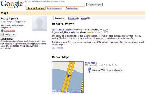
Maps can help us to connect better with communities of people that share our interests. At Platial, you can collaborate with others that share your interests to build community maps, such as this musical map of London or the world of bugs. Hikers, bikers, kayakers and other outdoor sports enthusiasts can share maps with detailed route information and pictures at Everytrail. With tools like these and Google’s My Maps, anyone can create a map covering the smallest niche.

Lastly, maps provide us an easy way to explore our world from our computer screen. We’ve been able to do this to a limited degree in the offline world with travel guides, but tools like flickr’s map and Panoramio allow you to get up close and personal with a country, city or even one of the wonders of the world.

Great pyramids

The king of this market is Google Earth, where you can layer just about anything onto high quality satellite imagery – pictures, videos, census data, congressional districts. My two favorite layers are GigaPan’s panoramic images and Rumsey Historical Maps.

What’s next for maps? The biggest thing I see is real-time or near real-time data on maps. You can already overlay movie showtimes, buses, airplanes and traffic. Imagine pulling up a map and seeing parking availability or which restaurants have tables available. If the information is tied to a location and can be collected and digitized, you’ll be able to see it on a map.

More on: maps

Posted in aol, geotagging, google, maps, yahoo | Comments Off on The quest for buried treasure in mapping