 Google Maps is now including estimated travel times in heavy traffic in its driving directions. The details on Google’s LatLong blog post are vague. The service is available in “a limited set of metropolitan areas.”
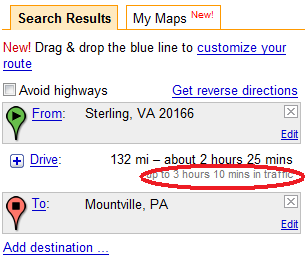
It looks like Google is using historical traffic data to make the estimates, instead of the live traffic data. There’s no indication of when the rush hours are or suggested alternate routes. (But you can drag to select an alternate route and have it recalculate estimated travel time.)
For a desktop mapping application, historical traffic data makes sense because accidents can occur (or be cleared) by the time you reach the point of any serious incidents. For in-car navigation, live traffic data is more useful. Still, it would be helpful to know what times Google considers rush hour.
Here are some of my previous entries on maps and traffic:

One response
apple green smoothie