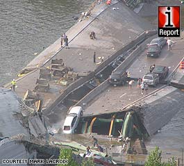
 The bridge that carries Interstate 35W over the Mississippi river collapsed tonight during rush hour. The picture at right was taken by a nearby resident who submitted it to CNN. They are reporting
 7 4 deaths.
Some good Web resources:
- NEW Video from MN-DOT traffic camera 628.
- Video of the actual collapse given to CNN.
- Live video from WCCO-TV.
- Live video from KARE-11.
- Information on construction on the bridge from MN-DOT.
- Google map of the area (35W is the bridge on the left).
- A few “before” pictures from flickr.
I suspect thatthis search on flickrwill sooncontains hundreds of “after” pictures. - Geo-tagged flickr map of the area. Don’t put too much stock in the precise locations; I doubt many people were out there with GPS units.
- An up-close shot from the riverbank.
- Photo gallery from startribune.com.
- CNN’s photo gallery of user-submitted pictures.
- MN-DOT traffic cameras. Cameras 627-629 were closest to the site of the collapse. Depending on which way camera 628 is facing, you might be able to see the gaping hole.
- Star Tribune graphic illustrating collapse.
- startribune.com comment board.
- Microsoft Live Search view of the area (35W is the bridge on the bottom). If you install the 3D viewer, you can do flyovers of the area.
I used to live in Minneapolis and would occasionally drive across the bridge. My thoughts go out to those affected.

One response
[…] extreme cases, such as when the Interstate 35W bridge in Minneapolis collapsed, a quick enough response could save […]